
Rectangular Survey System: Definition, Examples & Exam Tips
FOLLOW US
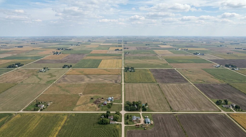
The rectangular survey system—also called the government survey system or public land survey system (PLSS)—is a method for dividing and describing land in the United States. It uses a grid made up of squares and rectangles to organize land into smaller sections. This system helps define property boundaries clearly and consistently.
Quick Answer: A land area divided by government lines is usually called a township in the U.S. rectangular survey system. A township is a 6-mile-by-6-mile square formed by township lines and range lines, and it contains 36 sections. Each section is one square mile, or 640 acres.
Note: Although some exam questions may use the word “rectangle” broadly, a standard township in the rectangular survey system is specifically a square. It measures 6 miles on each side and covers 36 square miles. That is why one township contains 36 sections, with each section measuring 1 square mile.
Crossword note: If the clue is “land area divided by government lines,” the answer is often township, although some puzzles may use section or range depending on the exact wording.
Let’s break it down in simple terms to help you understand how it works, where it’s used, and how it compares to older methods like the metes and bounds system.
What is the government rectangular survey system?
The rectangular survey system was created in 1785 as part of the Land Ordinance. At that time, the U.S. was growing beyond the original 13 colonies. The government needed a system to divide and measure land for sale and settlement. The result was the rectangular survey system.
Before this system, the metes and bounds method was used. It described land using natural features like trees, rivers, or rocks. While it worked locally, it wasn’t reliable for large areas. Landmarks could change or disappear over time, making it harder to identify property.
The government rectangular survey system solved this by using a standardized grid. Instead of relying on landmarks, it used principal meridians (north-south lines) and baselines (east-west lines) as starting points. These reference lines created a framework to divide the land into smaller, uniform sections.
How does the government’s rectangular survey system work?
The system works like a big grid. Imagine drawing straight lines on a map to divide the land into squares. Here’s how it’s organized:
- Principal meridians: North-south lines that act as main reference points.
- Baselines: East-west lines that cross the principal meridians.
- Range lines: These run north and south, parallel to the principal meridian. They divide the land into vertical columns called ranges.
- Township lines: These run east and west, parallel to the baseline. They divide the land into horizontal rows called townships.
When range lines and township lines intersect, they form squares called townships.
A principal meridian is the main north-south reference line for a survey area. The baseline is the east-west reference line. On the real estate exam, do not mix them up: principal meridians run north and south, while baselines run east and west.
Each principal meridian is named and serves a specific geographic area. For example, the Willamette Meridian is used for Oregon and Washington, while the Tallahassee Meridian is used for Florida and Alabama. The exact meridian matters because legal descriptions often identify land by township, range, section, and principal meridian.

Corrections
The earth is round, so lines drawn on maps need periodic adjustments to maintain accuracy. The rectangular survey system accounts for this through:
- Correction lines: These appear every 24 miles to adjust for the earth’s curvature.
- Guide meridians: These lines ensure grids remain consistent as they extend further north or south.
Without these adjustments, the grid would become distorted over long distances.
How Correction Lines, Guide Meridians, and Quadrangles Work
Correction lines and guide meridians help keep the rectangular survey grid accurate as it extends across the curved surface of the earth. Without periodic corrections, the grid would become distorted over long distances.
Correction lines appear every 24 miles. That distance equals four townships because each township is 6 miles wide. Guide meridians are also placed at 24-mile intervals to help correct the grid east and west of the principal meridian.
The 24-mile-square area formed by correction lines and guide meridians is often called a quadrangle or check. A standard quadrangle contains 16 townships because it is 4 townships wide by 4 townships tall.
Pass Your Real Estate Exam with Ease!
Get 100 FREE practice questions and unlock an exclusive discount on our top-rated exam prep – your first step to passing with confidence!
What is a township?
A township is a square that measures 6 miles on each side. It covers 36 square miles and is further divided into 36 sections.
Breaking down a township:
- Sections: Each section is 1 mile by 1 mile (640 acres). They are numbered in a unique serpentine pattern, starting in the top-right corner (Section 1) and ending in the bottom-right corner (Section 36).
- Half sections: Dividing a section in half creates a parcel of 320 acres.
- Quarter sections: Dividing a section into four parts creates 160-acre parcels.
- Smaller divisions: Quarter sections can be split again into 40-acre or 10-acre parcels.
For example:
“The southeast quarter of Section 12” refers to 160 acres in the bottom-right corner of Section 12 in a township.
Rectangular survey system vs. metes and bounds
Rectangular survey system:
- Uses a grid: Land is divided into squares and rectangles.
- Relies on reference lines: Principal meridians and baselines.
- Standardized: Accurate and consistent across large areas.
- Where it’s used: Most U.S. states that were formed after 1785.
Metes and bounds:
- Describes landmarks: Trees, rivers, roads, or rocks.
- Flexible: Works well in irregular landscapes.
- Challenges: Landmarks can change or disappear over time.
- “Where it’s used: Original 13 colonies and areas with Spanish or French influence, like Texas or Louisiana.
Texas has a hybrid system, part Spanish land grants described by metes and bounds, part its own rectangular surveys independent of the federal PLSS. The Texas real estate sales agent exam tests all three description methods. California overlays the PLSS onto earlier Spanish rancho boundaries, creating unique exam questions about conflicting descriptions. The California real estate salesperson exam covers both systems.
Accurate legal descriptions are essential because deed restrictions, such as setback requirements, building height limits, and use covenants, are enforced based on the property boundaries defined by the survey system. If a subdivision’s CC&Rs require a 25-foot setback from the property line, the rectangular survey system (or metes and bounds) determines exactly where that 25-foot line falls.
The Three Legal Description Systems on the Real Estate Exam
The rectangular survey system is one of the three major legal description systems tested on the real estate exam:
- Rectangular survey system: Uses principal meridians, baselines, townships, ranges, and sections.
- Metes and bounds: Uses distances, directions, monuments, and a point of beginning.
- Lot and block system: Uses numbered lots and blocks shown on a recorded plat map.
The lot and block system, also called the recorded plat system, is used mostly in subdivisions and urban areas. It often overlays land that was originally described by the rectangular survey system or metes and bounds.
Where is the rectangular survey system used?
The rectangular survey system is used in 36 states, mostly west of the original 13 colonies. These include:
- Western states: Washington, Oregon, California, Montana, and Nevada.
- Midwest states: Ohio, Illinois, Michigan, and Wisconsin.
- Southern states: Florida, Alabama, and Louisiana.
The metes and bounds system is still used in:
- The original 13 colonies: New York, Virginia, Massachusetts, etc.
- States with older surveying systems, like Texas and parts of Maine.
The real estate exam probably won’t ask you to name the states that use the Metes and Bounds system or the Rectangular Survey System. However, it may test you on the system used in your own state.

Not sure if you should get into a training program for the licensing exam? You can have a taste of what Lexawise can do for you.
Key features of the rectangular survey system
- Principal meridians and baselines: These are the starting points for dividing land.
- Townships: Squares measuring 6 miles on each side.
- Sections: Each township is divided into 36 sections, each 1 square mile (640 acres).
- Quadrangles: Larger squares, 24 miles on each side, made up of 16 townships.
- Correction lines: Adjustments made every 24 miles to account for the earth’s curvature.
When large tracts surveyed under the rectangular system are developed and sold with personal property included, furnished ranch homes, equipped agricultural properties, or turnkey commercial operations, the financing often uses a package mortgage that covers both the real property (described by the rectangular survey) and the personal property under a single loan. In rural and agricultural markets where the rectangular survey system is most prevalent, package mortgages are particularly common.
Utility companies rely heavily on the rectangular survey system to define their easements in gross, permanent access rights for power lines, pipelines, and drainage infrastructure that cross multiple properties. In the grid-based layout of the PLSS, these utility easements often follow section lines, quarter-section boundaries, or range lines. For property owners, this means that the same survey system that defines your boundaries also defines where utilities have the right to access your land.
Rectangular survey system examples
In the real estate licensing exam, questions about the rectangular survey system usually appear in two ways:
- Understanding land descriptions: You may need to interpret how a specific parcel of land is located using the system’s terminology.
- Calculating land size: You might be asked to determine the acreage of a described parcel by breaking it down into smaller sections.
Here are examples to help you prepare:
Interpreting land descriptions
Let’s say we’re describing a plot of land. The description might read:
“The northwest quarter of Section 3, Township 2 South, Range 4 West of the principal meridian.”
Here’s what this means:
- The land is in Section 3 of the township.
- The township is two rows south of the baseline (Township 2 South).
- It’s four columns west of the principal meridian (Range 4 West).
- The specific parcel is the northwest quarter of Section 3, which equals 160 acres (one-fourth of 640 acres).
This system works like an address, making it easier to locate land accurately.
Calculating land size
Knowing that one section equals 640 acres, you can calculate smaller parcels by dividing the land step by step.
For example:
“How many acres are in the southeast quarter of the northeast quarter of Section 10?”
- Start with the full section: 640 acres.
- Divide by 4 to find the northeast quarter: 640 ÷ 4 = 160 acres.
- Divide by 4 again to find the southeast quarter of that quarter: 160 ÷ 4 = 40 acres.
Answer: The parcel contains 40 acres.
Why the rectangular survey system matters today
The rectangular survey system remains essential for the following:
- Real estate transactions: Providing clear, standardized land descriptions.
- Land management: Simplifying property division and ownership records.
- Infrastructure planning: Shaping urban layouts, especially in grid-based cities.
Its uniformity and reliability make it indispensable for land use, even in modern times. That said, the rectangular survey is not used everywhere, Pennsylvania, as one of the original 13 colonies, still relies entirely on metes and bounds descriptions. The Pennsylvania real estate broker exam tests metes and bounds calculations rather than townships and sections. Tennessee, formed from North Carolina before the PLSS was adopted, also uses metes and bounds. The Tennessee real estate affiliate broker exam focuses on legal descriptions using compass bearings and distances rather than the rectangular grid.
The rectangular survey system does more than describe land, it defines the physical boundaries of the bundle of rights that each property owner holds. The rights to possess, control, enjoy, exclude others from, and dispose of property all depend on knowing exactly WHERE those property lines are. Without an accurate legal description, ownership rights cannot be established or transferred.
When buying or selling property, the legal description from the rectangular survey system appears in the purchase agreement, the bilateral contract between buyer and seller. An inaccurate or ambiguous legal description can void the contract entirely. The exam frequently tests this: ‘which of the following is required in a valid real estate contract?’, one answer is always ‘an adequate legal description of the property.’
Study Tip 💡
If you’re studying for the real estate exam, here’s what you should know:
- A township measures 6 miles on each side and contains 36 sections.
- Each section is 640 acres. Quarter sections are 160 acres, and smaller divisions follow.
- Be ready to calculate land sizes from descriptions like “the northeast quarter of the southeast quarter.”
Frequently Asked Questions
How are sections numbered in a township?
Sections are numbered 1 through 36 in a serpentine, or zigzag, pattern. Section 1 starts in the northeast corner, and Section 36 ends in the southeast corner.
Where is Section 1 located in a township?
Section 1 is located in the northeast corner of a township. From there, section numbering moves west across the top row and continues in a serpentine pattern.
Where is Section 36 located in a township?
Section 36 is located in the southeast corner of a township. It is the last section in the 1-through-36 township numbering pattern.
Is a township a rectangle or a square?
A standard township is a square, not just a rectangle. It measures 6 miles on each side and contains 36 square miles.
What is a principal meridian in real estate?
A principal meridian is the main north-south reference line used in the rectangular survey system. The baseline is the east-west reference line.
What are the three land description systems?
The three main legal description systems are the rectangular survey system, metes and bounds, and lot and block. The lot and block system is commonly used for subdivisions and urban property.
Wrapping-up
The rectangular survey system is a vital part of U.S. history and land management. Its grid-based structure makes it easy to divide, sell, and describe land. By understanding this system, you’ll not only be ready for the real estate exam but also gain insight into how land is organized in most of the country.
The rectangular survey system, metes and bounds, and lot and block are the three land description systems tested on every state licensing exam. Our real estate exam prep covers all three systems and every acreage calculation your state exam tests.