Government survey system explained at child level

FOLLOW US
Hey there! Today, we will explore something really interesting: the Government Survey System, also called the rectangular survey system. The U.S. government designed this system to identify, divide, and distribute land.
It all started in 1785 with the Land Ordinance and has been a big part of property mapping and finding since then. So, let’s explore the world of townships and sections and unravel how these elements simplify the process of describing and finding land parcels. It’s simpler than it sounds, we promise!
What is the Government Survey System?
Imagine a giant grid spread across the land; that’s basically what the Government Survey System is all about. Like a big map, it simplifies discussions about the location and division of land.
Picture some main lines, called baselines and principal meridians, crisscrossing each other. They form these neat little boxes called townships and sections where they meet. This excellent arrangement means we can quickly pinpoint any piece of land.

Are you skeptical about the help that Lexawise can give you? That’s OK, you can try our free exam to see it for yourself.
The Purpose of the Government Survey System
The primary purpose of the Government Survey System is to facilitate the sale, distribution, and management of land. It does that by dividing the country into squares called townships and sections. That makes it easier for people who own land and surveyors (people who measure land) to locate and describe exact parcels. It also helps maintain peace by clearly defining where one person’s land ends and another’s begins, ensuring smooth land management.
Understanding Townships
Let’s talk about townships. Think of them as the building blocks of land measurement. Each township is like a big, 36-square-mile patchwork quilt. Townships form where range lines (which run north to south) and tier lines (going east to west) cross each other.
Every township has a unique position on the map, determined by its proximity to two main lines: the baseline and the principal meridian. It’s similar to locating a specific, numbered seat in a large theater.

The Structure of a Township
Picture a township as a puzzle comprising 36 pieces, each being a section. The numbering of these sections follows a unique pattern, resembling a snake game. It starts at the northeast corner (top right corner), counting right to left, then snakes its way across the township all the way to the southeast corner (bottom right).
This cool zigzag pattern isn’t just for fun; it was conducive for surveyors back in the day. It allowed them to walk through the township and mark the land without missing a beat.

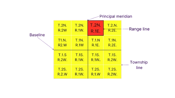
Locating a Township
Let’s turn into land detectives for a moment! Finding a specific township is like using a treasure map. First, you need to discover where it is with two crucial clues: the baseline, which runs east-west, and the principal meridian, which runs north-south.
The secret code to unlock its location is a mix of numbers and letters. You’ll see something like ‘T.2N., R.1E.’ This is a fancy way of saying, ‘Township 2 North, Range 1 East.’ It tells us the township is two steps north and one step east from where the baseline and the principal meridian cross.
Understanding Sections
Sections help break down the township into smaller, more manageable parts. Each section is like a neat, one-square-mile patch of land, which adds up to 640 acres.
Now, how do we know where one section ends and another begins? It’s all thanks to the range and tier lines that crisscross around them, like lines on a game board, defining their borders. So, a township is like a board game; the sections are the individual squares on the board!
Numbering and Describing Sections
Sections start with number 1 in the northeast corner and zigzag all the way to 36. That is not just to make it look attractive; it’s a clever way to assign every little parcel of land its unique address.
Just as you can divide a chocolate bar into smaller pieces, you can also split these sections into halves and quarters. That simplifies the process of locating and describing a specific land lot.
Looking for top-notch real estate exam prep?
Enroll now with our preparation exams with more than 20K questions, a real estate AI Chat Tutor, flashcards, exams by category, practice exams, and simulated exams.
Locating a Section within a Township
To locate a specific section in a township, just look for its number. It’s like following a numbered guide on an extensive grid. For instance, to find Section 8, you simply follow the numbers until you reach the right spot in the township’s layout. It’s straightforward; each section has its unique number, making it easy to locate.
Describing Land within Townships and Sections
The Government Survey System is like a tree with branches that break down land descriptions. It begins with the big branch, the township, and then narrows down to smaller branches, the sections. And it doesn’t stop there; within each section are even smaller twigs, the subunits. It’s a step-by-step approach, going from the most significant piece of the puzzle right down to the tiniest pieces within the sections.

Understand Economic Obsolescence right now in this article; don’t miss the opportunity!
Understanding the Legal Descriptions
Legal descriptions in the Government Survey System are like a detailed recipe for locating a property. They follow a set format, giving you all the specifics about where a property sits within a township and section. It includes divisions like the quarter, quarter-quarter, and other parts of the section, topped off with the township and range info.
Example Legal Description
Take an example legal description: NE1/4 of NW1/4 of Section 6, T.3N., R.2E. You can interpret this description as the northeast quarter of the northwest quarter of Section 6 in Township 3 North and Range 2 East.

Reading Legal Descriptions
Getting the hang of reading legal descriptions in the Government Survey System can feel like learning a new language at first. But there’s a trick to make it easier. Start with the most detailed part of the description, like the quarter-quarter.
It’s like zooming in on the smallest detail. Then, gradually zoom out to the more extensive parts, like the quarter section, and eventually, you’ll get to the broader details, like the township and range. It’s a step-by-step journey from the most specific to the general.